$1,850$2,000/
Per Person
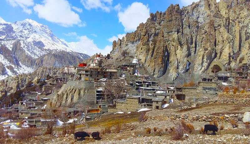
Looking for a trek that combines serious high-altitude challenge with authentic Tibetan Buddhist culture, all without the crowds? The Manaslu Tsum Valley Trek delivers exactly that. This 19-day journey takes you into one of Nepal’s most protected corners, where ancient monasteries cling to cliffsides and the Tsumba people live much as they have for centuries.
In this blog, you’ll find everything you need to know about the Manaslu Tsum Valley Trek, including the complete day-by-day itinerary, altitude profile, difficulty level, permit requirements, trek cost, accommodation options, best trekking seasons, and how to prepare. Whether you’re planning your first restricted area trek or adding another Himalayan adventure to your list, this guide covers it all.
What Is the Manaslu Tsum Valley Trek?
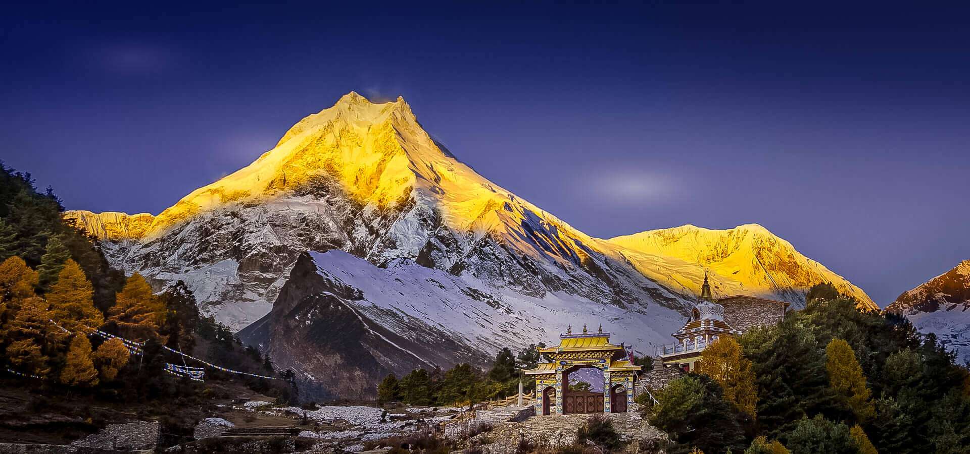
The Manaslu Tsum Valley Trek is a 19-day teahouse journey that combines the dramatic Larkya La Pass crossing at 5,160 meters with an exploration of the sacred Tsum Valley, a hidden Buddhist beyul that remained closed to outsiders until 2008. The route takes you close to Mount Manaslu, the world’s eighth-highest peak at 8,163 meters, while immersing you in Tibetan Buddhist culture that feels untouched in ways that are increasingly rare in Nepal.
What sets this trek apart from the Manaslu Circuit is the detour into Tsum Valley. Ancient monasteries cling to cliffsides here. Prayer flags stretch across gorges. The Tsumba people maintain traditions largely unchanged for centuries. You get two distinct experiences woven into a single journey, combining high-altitude adventure with deep cultural immersion.
- Sacred Tsum Valley: Explore the hidden Buddhist beyul with ancient monasteries and Tibetan culture
- Larkya La Pass Crossing: Summit the trek’s highest point for panoramic Himalayan views
- Mount Manaslu Views: Trek beneath the world’s eighth-tallest peak
- Off-the-Beaten-Path Trails: Experience far fewer trekkers than Everest or Annapurna regions
Manaslu Tsum Valley Trek Route and Map
The Manaslu Tsum Valley Trek follows a figure-eight pattern through the Manaslu region, combining two distinct loops into one comprehensive journey. The route starts from Machha Khola at 930 meters, following the Budhi Gandaki River north before branching west into the sacred Tsum Valley. After exploring Upper Tsum and its ancient monasteries, you return to the main trail and continue north around Mount Manaslu toward the Larkya La Pass.
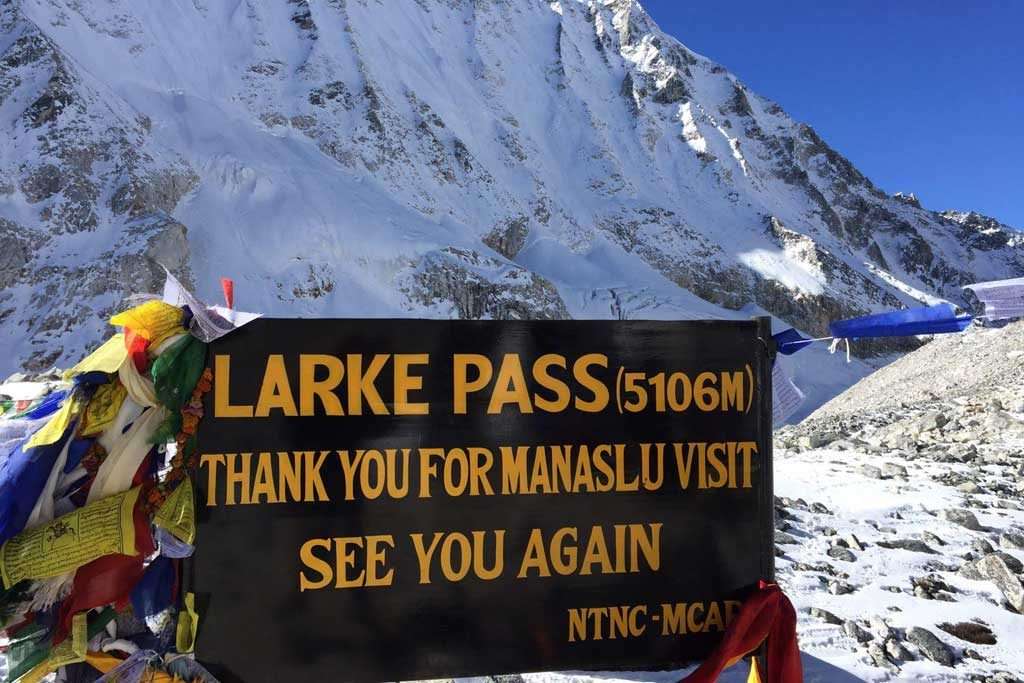
The Larkya La Pass crossing at 5,160 meters marks the trek’s climax and highest point, offering panoramic views of Manaslu, Himlung, and Cheo Himal. From the pass, you descend the western side of the circuit through Bimthang to Dharapani, where the trail meets the Annapurna Circuit. Key geographical features along the route include the Budhi Gandaki Gorge, the Larkya Glacier, and the dramatic amphitheater surrounding Manaslu Base Camp. The entire route covers approximately 177 kilometers of trekking distance over varied terrain ranging from subtropical river valleys to high-altitude glacial zones.
Conservation Area Permit
The conservation fee of $30 supports local communities and environmental protection throughout the Manaslu region. This permit is standard for all trekkers entering the conservation area. Revenue from this permit funds trail maintenance, waste management programs, and wildlife conservation efforts in the region.
Annapurna Conservation Area Permit
Because the trek exits through Dharapani in the Annapurna region, you also require this $30 permit for the final section of the route. The permit covers the last two days of trekking after crossing Larkya La Pass and descending into the Annapurna Conservation Area.
How Difficult Is the Manaslu Tsum Valley Trek?
The Manaslu Tsum Valley Trek falls into the moderate to challenging category with the primary difficulty coming from the Larkya La Pass crossing at 5,160 meters. The overall route demands consistent fitness over 19 days of walking, though the itinerary builds in acclimatization gradually to help your body adjust to higher elevations.
Most trekkers with good physical conditioning and prior multi-day trekking experience can complete this route successfully. The trek involves daily walking for 5 to 7 hours on most days, with 8 to 10 hours required on pass day. No technical climbing skills are needed, though pass day involves steep ascent and descent on loose rock that requires careful footing.
Key difficulty factors include:
- Maximum Altitude: Larkya La Pass at 5,160 meters (16,929 feet)
- Daily Trekking Hours: Typically 5 to 7 hours, with 8 to 10 hours on pass day
- Terrain: River gorges, forest trails, high-altitude moraines, and glacial crossings
- Technical Skills: No technical climbing required, though pass day involves steep ascent and descent on loose rock
The itinerary includes time in Tsum Valley at moderate elevations before ascending to higher camps. The rest day at Samagaon allows your body to adjust before the pass crossing, which makes a significant difference in how you handle the altitude on summit day.
When Is the Best Time to Do the Manaslu Tsum Valley Trek?
The best time to do the Manaslu Tsum Valley Trek is during spring (March to May) or autumn (September to November) when weather patterns create optimal trail conditions, clear visibility, and safe pass crossings. These two seasons offer the most reliable weather windows for completing the trek successfully.
Weather determines everything on this trek, from trail conditions to mountain visibility to whether Larkya La Pass remains open. Winter snow can block the pass entirely, while monsoon rains create slippery trails and limited visibility. Choosing the right season makes the difference between a successful trek and a difficult or incomplete journey.
Spring Season (March to May)
March through May brings warming temperatures and rhododendron blooms in the lower forests. Mountain views are generally clear, though afternoon clouds can build as the day progresses. This pre-monsoon window offers excellent trekking conditions with fewer crowds than autumn, making it ideal for trekkers who prefer quieter trails.
Autumn Season (September to November)
September through November delivers the most stable weather and clearest skies of the year. Post-monsoon conditions mean dry trails and spectacular visibility. This is the best time to trek in Nepal, so expect more trekkers on the main circuit, though Tsum Valley remains quiet even in peak season.
Winter and Monsoon Trekking
December through February brings heavy snow that can block Larkya La Pass entirely, making the trek impossible to complete. June through August monsoon rains make trails slippery and leeches abundant in lower sections. Both seasons present significant challenges and are best avoided unless you have extensive high-altitude experience and flexible timing to wait out weather delays.
What Accommodation and Meals Are Available on the Manaslu Tsum Valley Trail?
Accommodation on the Manaslu Tsum Valley Trek consists of teahouse lodging, which means staying in basic mountain lodges rather than camping. These family-run guesthouses provide shared rooms with twin beds, communal dining areas, and simple toilet facilities that differ significantly from hotel standards.
Meals follow a predictable pattern throughout the trek. Dal bhat (lentils, rice, and vegetables), noodle soups, fried rice, and chapati with curry make up the core menu options. Hot drinks including tea, coffee, and hot lemon are available throughout the day. Tsum Valley teahouses tend to be more basic than those on the main Manaslu Circuit, with simpler menus and fewer amenities.
Hot showers and device charging typically cost extra, usually 200 to 500 Nepali rupees per use. Bringing a power bank and quick-dry towel helps reduce these expenses and keeps you more comfortable. Teahouse conditions become more basic as you gain elevation, with the most remote lodges offering minimal facilities but warm hospitality.
What Are the Permit, Guide, and Group Size Rules for Restricted Area Treks?
The Manaslu Tsum Valley Trek requires a minimum group size of two trekkers and a licensed guide arranged through a registered trekking agency. The restricted area designation creates specific requirements that differ from open trekking regions like Annapurna or Langtang, and these rules are strictly enforced at checkpoints along the route.
Key requirements include:
- Minimum Group Size: Two trekkers required, meaning solo trekking is not permitted
- Licensed Guide: Mandatory, not optional, and arranged through a registered agency
- Permit Processing: Only available through government-registered trekking companies
- Documentation: Passport copies and photos required for permit applications
These rules, similar to those governing the Upper Mustang Trek, exist to protect the region’s cultural heritage and environment while ensuring trekker safety in remote areas with limited infrastructure. Checkpoints verify permits at multiple points along the route, and attempting to trek without proper documentation results in fines or removal from the trail.
What Travel Insurance Do You Need for the Manaslu Tsum Valley Trek?
Travel insurance is mandatory for the Manaslu Tsum Valley Trek, and your policy must include specific coverage for high-altitude trekking and emergency helicopter evacuation. Standard travel insurance often excludes trekking above 3,000 meters, so you need to verify coverage details carefully before purchasing.
Required coverage elements include:
- Altitude Coverage: Policy covering trekking up to at least 5,500 meters
- Helicopter Evacuation: Emergency evacuation coverage, which is essential since ground evacuation is often impossible
- Medical Treatment: Coverage for high-altitude illness and injury treatment
- Repatriation: Coverage for medical repatriation if required
In an emergency, your guide coordinates helicopter evacuation to Kathmandu. Insurance handles costs directly with evacuation companies in most cases. Carrying a printed copy of your policy with emergency contact numbers is essential since phone signal is unreliable throughout most of the trek.
How Can You Trek Responsibly in the Tsum Valley Restricted Region?
Responsible trekking in Tsum Valley means respecting the region’s deep spiritual significance as a Buddhist “beyul,” which translates roughly to “hidden sacred valley.” Your behavior directly impacts whether this protected area remains open to trekkers and whether local traditions continue to thrive.
Essential responsible trekking practices include:
- Leave No Trace: Pack out all trash including wrappers and tissues
- Respect Monasteries: Follow dress codes, remove shoes when asked, and request permission before photographing
- Support Local Economy: Stay in local teahouses and hire local porters
- Preserve Culture: Interact respectfully with Tsumba communities and avoid disrupting religious practices
The restricted status exists partly to protect these traditions. Trekkers who visit with awareness and respect help ensure the valley remains open for future visitors while supporting the communities that call this sacred valley home.
Book Your Manaslu Tsum Valley Trek With Wilder Way Trekking
The Manaslu Tsum Valley Trek combines adventure, culture, and remote Himalayan beauty in a way few other routes can match. From the sacred monasteries of Tsum to the dramatic Larkya La crossing, this 19-day journey delivers experiences that stay with you long after you return home.
Wilder Way Trekkinghandles all permits, logistics, and guide arrangements as a government-registered operator with deep Manaslu region expertise. Transparent pricing with taxes included, flexible booking options, and support throughout your trek mean you can focus on the experience while the details are handled for you.
Pricing Packages
19 Days from US$ 2000 US$ 1850 pp
Save $150 Per Pax
Group-Size Discounts
Discounts are based on your group size.
We do not add anyone to your group. | No. of Persons | Price per Person |
| 1 Pax | US$ |
| 2 - 4 Pax | US$ 1850 |
| 5 - 8 Pax | US$ 1830 |
| 9 - 15 Pax | US$ 1800 |
Included and Excluded
- Transportation from Kathmandu via Arughat to Soti Khola (trek start) and from Tal (trek end) to Besisahar, then back to Kathmandu by local bus.
- All standard full-board meals (19 Lunches, 18 Dinners, and 19 Breakfasts) during the trek
- Accommodations at best tea houses/ lodges in trek regions (Generally twin sharing rooms) for 18 days.
- Government licensed English-speaking Wilder Way Trekking trek leader/ guide and porter to carry your luggage. For every two trekkers, we assign a porter. The luggage weight limit per trekker is 9 kg.
- Guides and porter cost, their meals, insurance, salary, lodging, transportation, and other necessary equipment
- Manaslu & Tsum Valley Special Permits with Conservation Area Permits, and Annapurna Conservation Area Permit (ACAP) fees
- Water purification tablets for safe drinking water
- Snacks (cookies) and seasonal fresh fruits every day
- All government, local taxes, and official expenses
- Rescue operation arrangements in case of complicated health conditions
- Souvenir - Company's T-shirt & cap
- Wilder Way Trekking trek achievement certificate
- Farewell dinner in Kathmandu at the end of the trek
- International flight costs.
- Nepal entry visa fees at Tribhuvan International Airport
- Excess baggage charges (Limit is 9 kg per person)
- All accommodations and meals in Kathmandu, before and after the journey
- Extra night accommodation in Kathmandu due to early arrival, late departure, or early return from the trek.
- Personal expenses - shopping, snacks, boil bottle water, hot (tea/coffee) and cold drinks, hot shower, alcohol, Wi-Fi, telephone call, battery re-charge fee, laundry, extra porters, etc
- Personal clothing and gear
- Travel insurance which has to cover emergency high-altitude rescue and evacuation (compulsory)
- Tips for guide and porters
- Additional costs or delays caused due to circumstances beyond our control, for example, landslide, weather condition, itinerary modification due to safety concerns, illness, change of government policies, strikes, etc.
- All costs and expenses not listed in "cost includes" are counted as excludes
Highlights of the Tour
- Scenic drive from Kathmandu to Soti Khola
- Mu & Lungdang Gompas in Tsum valley
- Milarepa Piren Phu Cave (pigeon cave), the most sacred cave in the Tsum Valley
- Dephyudonma and Rachen monastery - the oldest monasteries in the Tsum valley
- Trek around Mt Manaslu (8,163 m) - the worlds eighth tallest mountain
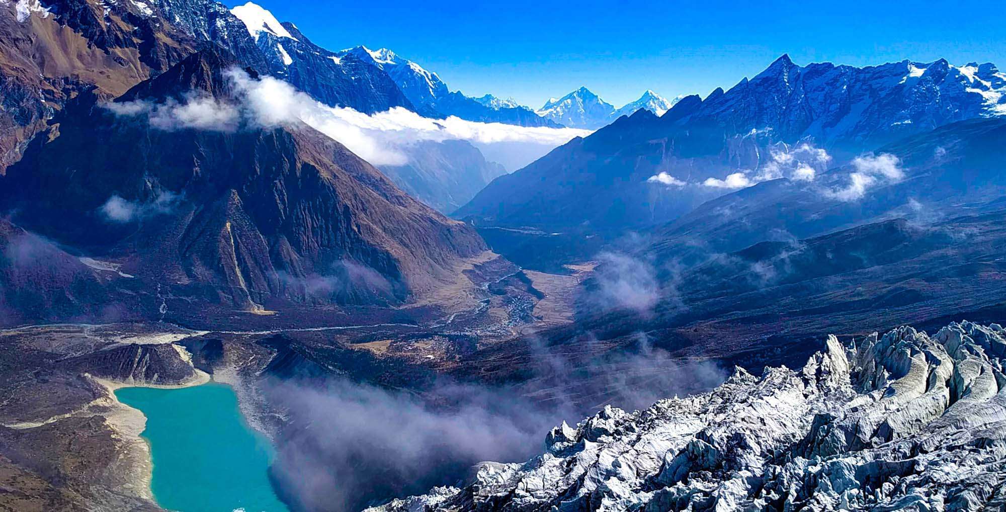
- Side trip to Birendra Lake, Punhyen Glacier, or Mount Manaslu Base Camp during the rest day at Samagaun
- Majestic views of glaciers, lakes, rocks, and mountains - Manasalu, Himchuli, Ganesh, and many more on Nepal- Tibet border
- Cross Larkya La Pass ( 5,106m) - one of the longest passes in the Himalayas
- The unique cultural blend of Tibetan Nupri and Gurung inhabitants
- Ancient Buddhist stupas, monasteries, and Tibetan lifestyle
- Less crowded path
- An ancient trading route to Tibet
Itinerary
After an early breakfast, we will start our trip with a drive along the Prithivi Highway west of Kathmandu. The scenic ride lets you enjoy the views of terrace farms, raging rivers, beautiful villages, and dense forests. You will be crossing the Trishuli River to Dhading Bensi and continue to Arughat, driving along with the scenic villages while continuously following Dorandi Khola northwards to Gorkha. From the road, you get stunning views of Manaslu and Ganesh Himal. Our destination, however, is still two hours drive away from Arughat to Soti Khola.
We continue to follow the low valley to the north, observing the majestic Himalayan peaks from time to time as we hike up the picturesque densely forested Buddhi Gandaki Valley. The route passes through several small villages until the valley widens. From the opposite side of the valley, you will see a large stream flowing into the Budhi Gandaki River. As we continue our journey, we reach the beautiful village of Lapubesi (880m). From Lapubesi, we descend to a meandering path to reach Macha Khola.
We cross the Tharo Khola river and head upstream to Khola Beni. The route takes your forward alongside dramatic gorges with waterfall sculptured rocks and some landslides. After crossing a bridge, we reach a tiny village of Kholabesi and then natural hot springs at Tatopani (Tatopani means hot water in Nepali). From the hot springs, we catch another trial and cross the Budhi Gandaki River on a suspension bridge. We will then walk past a landslide and reach Dobhan village. From Doban, we cross a suspension bridge over the Yaru Khola and climb stone stairs to Thado Bharyang before ascending to the charming village of Jagat. Jagat is the entry point of Manaslu Conservation Area, and we will register our permits at a police checkpoint in Jagat.
We make an entry into the restricted region of Manaslu by climbing over a ridge to Salleri. We walk along the riverbanks then cross the Budhi Gandaki River on a long suspension bridge. As we continue to walk, the valley widens towards Philim. As we pass Ekle Bhatti, the trail separates one takes you to Tsum and the other Manaslu. We hike up towards Lokpa across several villages. Rivers become narrower, and we can see the confluence of Syar Rivers from Tsum valley. We trek on the right side of Tsum valley to reach Lokpa village, the first village in Tsum valley that provides clear views of the Manaslu range. In fact, it’s a completely hidden valley blessed by Padmashamva centuries ago. (Padmashamva is one of the founding fathers of Tibetan Buddhism.) You will get stunning views of Himalchuli, and Boudha Himal from Lokpa village.
After breakfast, we start walking from Lokpa Village- a wild route entrance to Tsum valley. On a clear day, you can get stunning views of Baudha Himal (6672m) and Ganesh Himal VI from the routes joining Lokpa to Chumling. Our trail first descends to Lungwa river valley, then climbs up through a subtropical forest of dense rhododendron and pine. There are no villages between Lokpa to Chumling. We will be crossing Syar Khola to arrive at the village of Chumling. A side trip to the upper parts of Chumling takes you to a monastery from where you can catch great views of Ganesh Himal. Chumling has a health post and three monasteries - Panago Gumba, Mani Dhungyur, and Gurwa Gumba.
Today, we enter the upper valley, a part of the inner Himalayas. The trail continues along the Syar River down to Domje - the largest city in Tsum valley. From Domje, we continue climbing uphill to arrive at Chhokangparo. On a clear day, we can get magnificent views of Himalchuli and Ganesh Himal from Chhokangparo. At Chhokangparo, you will also have the opportunity to experience the hospitality of local (Tibetan group “Tsombo”) people along with Tibetan Chiya (butter tea) and local meals.
We walk a relatively shorter distance today. The Nile, on the western side of the Shikhar Khola, is about a 20-minute walk across from Chhule, which is the last village in the north upper Tsum Valley. When you reach Ngakyu Leru, you will notice people farming as the land is fertile. After passing Lamagaon, you will reach St. Milarepa Piren Phu Cave, where his footprint is said to be preserved in rock. Piren Phu (pigeon cave) is one of the most sacred caves in the Tsum valley. There are two separate Gumbas attached to the rocky cave. Richly painted Buddhist murals, excellent artistic scripts carved on stones, long prayer flags, and significant Buddhist paper scripts make Piren Phu Cave one of the most important socio-cultural assets in the valley. Then, we cross a suspension bridge over the Shiar River and continue our trek through several villages to arrive at Nile.
A short walk from the Nile along the west bank of the valley close to the Tibetan border leads to Mu Gompa - the highest point of the Tsum Valley Trek. We hike up through yak pastures through typical dry and arid trans Himalayan terrain. The Mu Gompa monastery has rows of Chortens and provides beautiful mountain views. Moreover, you get an opportunity to visit Dhephu Doma Gompa - one of the oldest monasteries in the Tsum.
From Gompa, the descent begins. We descend to Rachen Gompa, then Chhule and reach Phurbe. Rachen Gompa lies in the border area of Nepal and Tibet, and it sits surrounded by humongous mountains. But the destination for this day takes you through a forested area and finally at Chhokangparo.
Our descent from Chhokung Paro continues as we reach Gho. You will be crossing a suspension bridge near Gho and hiking forward to reach Rainjam Village. We leave Rainjam village, descend to Tsum Valley and finally reach Chumling - our destination for the day.
Today, you will leave Chumling and continue descending, so today's journey should be an easier one. You will be moving along the bank of Shair Khola to reach Lokpa Village. On a nice day, you may pass through large flocks of sheep and goats along the path. The trail after Lokpa descends as we cross the Budi Gandaki on a solid bridge then enters a narrow gorge from where it starts to ascend and descend while gradually climbing through the valley. We cross a river on a suspension to Nupri and then pass through bamboo forests to reach the Gurung village of Deng (1860m).
From Deng, we climb to Rana (1,910m) Village and hike forward to Bhiphedi (2,130m). The path starts meandering in and out of the valley canyons crossing the Serang Khola before leading us to Ghap (2160m). As we leave Ghap, the valley becomes steeper as we continue a long climb through bamboo and rhododendron forests. After crossing the wild rivers a couple of times, you will reach the Namrung Village - the entry point to the Nupri region. The locals of Namrung Village are Tibetan descendants.
We leave Namrung and pass through many Mani wall entrance gates, several Buddhist Gompas, and a few villages. Then the valley opens out, and our route passes through Sho Village. This village has many yaks and is known for excellent views of Manaslu (8163m) and Manaslu North (7,157m). It is a great day to savor the great mountain views. To trek to Sama Gaon (3530m), we follow the right riverbank enjoying the views of Peak 29. A couple of hours of climbing through the forest brings us to Shyala village, from where we can see Phungi, Manaslu, and Himal Chuli mountains. The Shyala villagers rely on yaks, potatoes, and barley to survive this distinctly Alpine region. As we hike up, you will see Ganesh Himal towards the east and the Himalchuli and Manaslu in the south. Soon enough, as you look down, you will be able to see two rows of houses that form the central part of Sama Gaon. At the far end of Sama Gaon stands the well-known Sama Gaon Monastery. The Tibetan border is very near from here. We stop at Samagaon for a day to acclimatize.
To ensure proper acclimatization, we spend a day at Sama Gaon for rest. Sama Gaon lies close to Manaslu Base Camp, and in this village, you can see thousands of mani stones with Buddhist texts and sculptures. The women here wear a nice silver spoon as jewelry. Today is a rest day, but you can take optional excursions to explore the surrounding glacial moraine or visit Birendra Lake or Pungyen Gompa. The return side trip to Manaslu Base Camp takes eight hours but is well worth the effort as it provides fantastic views of the Manaslu Glacier and the turquoise Birendra Lake. If you just want to explore Sama Gaon and relax, you can visit the Pung-Gyen monastery, which sits beneath the east face of Manaslu. Higher up the village lies cave Gompa and hot springs.
We start early in the morning from Sama Gaon and head to Samdo. Our hike takes us through the terraced fields alongside old mani walls, across the Budhi Gandaki wooden bridge, and gradually up to the Samdo valley. Another mani wall marks the beginning of the ascent to the Larkya La Pass. We cross two streams and witness the Larkya Glacier. Then, we go around the Salka Khola Valley, climb up once again and come to a stone guest house (4,450 m), which is not a lodge but a kind of resting place called Dharmasala, also known as Larkya La Phedi. Today you will enjoy fantastic views of Larkya Glacier and the impressive Manaslu mountain. We rest at Larkya La Phedi and prepare to cross Larkya La Pass the next day.
We leave Dharmasala very early in the morning because we will be hiking along the longest and the toughest section of this trek. We need to cross the Larkya La Pass (5,160m) before the wind starts blowing strongly at the pass. The trail starts as a gentle climb across the moraine. It descends slightly to a lake and then becomes rough and indistinct as it crosses steep grassy slopes. We continue on the moraine to a ridge marked by two cairns. From here, the prayer flags marking the pass are visible. We descend to the four frozen lakes then make the final steep climb to the pass. The pass opens outstanding panoramic views of Himlung Himal, Cheo Himal, Kanguru, Minjung, and the huge Annapurna II. We savor the spectacular views from the top of the pass. Then the descent begins. The trail follows the top of the moraine to the west and makes a set of steep, rough switchbacks as it crosses the moraine, then descends more gently on loose gravel to another grassy moraine at 4,450m. The trail now becomes easier to follow and reaches a small meadow. The valley becomes broader as the trails head down to a large meadow, past a mani wall and a small rest house that marks Bhimtang at 3,590m.
From Bhimtang, the trail crosses the moraine, descends to the Dudh Khola headwaters, crosses a wooden bridge, then into pine and rhododendron forest to Hompuk (3,430m). The rhododendrons are multi-colored, and the forest is home to sheep, horses, and monkeys. You will also be able to enjoy the panoramic views of Phungi, Manaslu, Manaslu North Peak, Cheo Himal, and Himlung Himal. A 30-minute descent through the forest takes you to Sangore Kharka meadow. You will then cross a landslide before making a steep climb to a ridge decorated with prayer flags. The route ultimately descends to the river bank at Gho (2,575m).
The route is full of ups and downs, mostly through fields but occasionally through dense forests. Less than an hour walk through the fields and intermittent rhododendron and oak woods takes you to Tilije - a multiethnic community. You will exit Tilije through a stone arch, cross the Dudh Khola and follow along its embankment that descends through the scrub forest. As you trek ahead, the walls of the Marsyangdi Valley start to look larger, and finally, the houses of Dharapani appear in the distance. You will then pass Thonje village via a wooden bridge and a chorten-shaped arch, and Dharapani lies across a long suspension bridge over the Marsyangdi. But your trail continues on the sandy banks of the Marsyangdi River until you reach Tal. The prayer flags, mani walls, and chortens in and around Tal tell you that Tal is a Buddhist village.
In the morning, we take a local Jeep or bus from Tal to Besisahar. It is an approximately 4 to 5 hrs drive that passes through several villages, the towns of Bhulbhule and Khudi to Beshishar. We need to reach Besisahar before 3 p.m to catch the last jeep or local bus to Kathmandu. On our journey back to Kathmandu, the road follows the scenic Marsyangdi River, then meets the Trishuli River as we head east along the Prithvi Highway. Along the way, you will get good views of the lush scenery, terraced farmland, and perhaps some final glimpses of the tall snow peaks.
Route Map
Click to View Full Route Map
Frequently Asked & Question
Booking a trip on our website is easy and accessible. Simply browse through the trekking packages available and select the trip that suits your interest. Click on the" Book Now" button on the package runner, fill in your particular details and favored trip dates, and do with the secure payment process. Once your booking is verified, you'll admit a evidence dispatch with all the necessary trip details and farther instructions. However, our support platoon is always ready to help, If you encounter any issues or need backing during the booking process.
In Nepal, we accept a range of payment styles for your convenience. These include major credit and debit cards( Visa, MasterCard, American Express), as well as popular online payment platforms like PayPal. We also accept bank transfers and payments via eSewa or Khalti, which are generally used digital holdalls in Nepal. For any other payment options or backing, please communicate us, and we’ll be happy to help.
Yes, you can make changes to your reservation after booking, but it is subject to availability and certain conditions. If you need to modify your travel dates, trekking package, or any other details, please contact us as soon as possible. We will do our best to accommodate your requests, but please note that changes may incur additional fees, depending on the nature of the modification and the time remaining before the trip. We recommend contacting us at least a few weeks in advance for smoother adjustments.
Yes, we offer group booking discounts for larger parties. If you are booking for a group, the discount amount depends on the size of the group and the specific trekking package. Typically, groups of 3 or more participants are eligible for a discount. For exact pricing and discount details, please contact us directly with your group’s size and the trek you’re interested in. We’re happy to offer customized packages and ensure a great experience for your entire group!
The combined trek adds several days exploring Tsum Valley at moderate elevations before the challenging Larkya La crossing. If the pass feels too demanding, the dedicated Tsum Valley Trek covers this sacred region without the Larkya La crossing. For those who do the combined route, the extra acclimatization actually makes the pass crossing potentially easier than on the shorter standard circuit.
No. Both Manaslu and Tsum Valley are restricted areas requiring a minimum group of two trekkers and a licensed guide arranged through a registered agency. This rule is enforced at checkpoints.
Mobile signal is limited or absent throughout Tsum Valley, and Wi-Fi is generally unavailable in the more remote teahouses. Plan for minimal connectivity during the trek and let people know before you leave.
Tipping is customary and appreciated in Nepal. Your trekking agency can provide current guidelines based on trip duration and service quality. Typical amounts run $15-20 per day for guides and $10-15 per day for porters.
No ATMs exist once you leave Kathmandu. Withdraw sufficient Nepali rupees before departing. Typically 30,000-50,000 NPR covers personal expenses, hot showers, charging, and tips.
Fit individuals of various ages can complete this trek, though the high-altitude pass crossing requires good physical conditioning. Prior trekking experience at altitude is strongly recommended for anyone attempting this route.
If the pass is blocked by snow or unsafe conditions, your guide arranges an alternative route or extends the itinerary until crossing is safe. Building flexibility into your travel schedule helps accommodate weather delays.
Beyond the amounts mentioned above, carrying 20,000-30,000 NPR covers snacks, drinks, souvenirs, and unexpected expenses. Your trekking agency can suggest a suitable amount based on your preferences and spending habits.